Drones give you the best perspective on the health of your pastures and paddocks.
As the size of horse properties get smaller, pasture management becomes more important to maintaining healthy grazing options. Winter is the hardest season on pastures due to the wet soil conditions that are easily torn up by horses. Grass roots can be damaged, leaving bare spots and opening the door for more weeds and less forage for your horses to eat during the summer. Fixing the damage through reseeding and fertilizing is an annual summer event. Proper maintenance prevents weeds and bare spots in your pasture. But what is the best way to make an accurate assessment of your pastures so you can maximize your efforts during the summer growing season? Aerial drone inspection is the best way to get the true overall perspective of pasture condition.
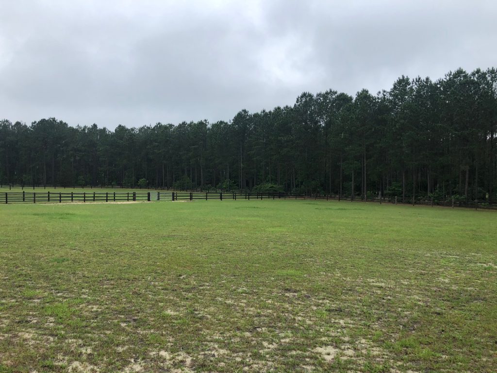
The small .885-acre paddock below is used for daily turnout for 3 large sport horses. The horses are periodically rotated between 2 other fields to help the grass recover. In the fall, winter, and spring the horses spend 6-8 hours during the day turned out and are in their stalls at night. In the summer, due to the bugs and heat, the horses are turned out 8-12 hours overnight spending the day in their stalls.
From the visual ground perspective in late May 2020, you can see some bare spots, but overall, the summer grass is coming back to life and looks green and healthy.
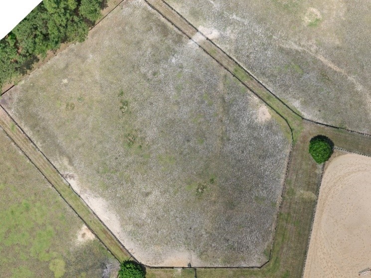
Unfortunately, the aerial perspective shows a different story. Taken 2 days before the above picture, you can clearly see bare spots throughout the field, with larger bare patches along the fence line.
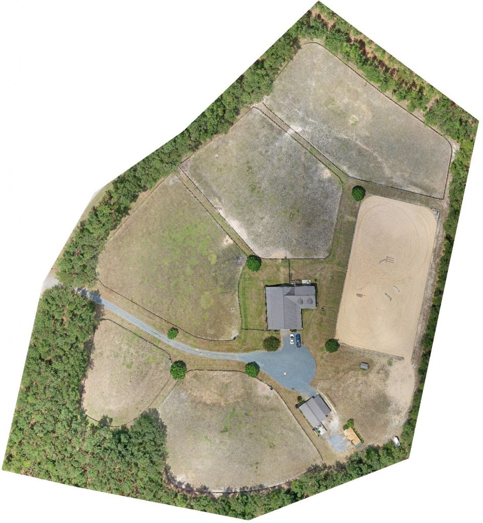
Mapping with a Drone
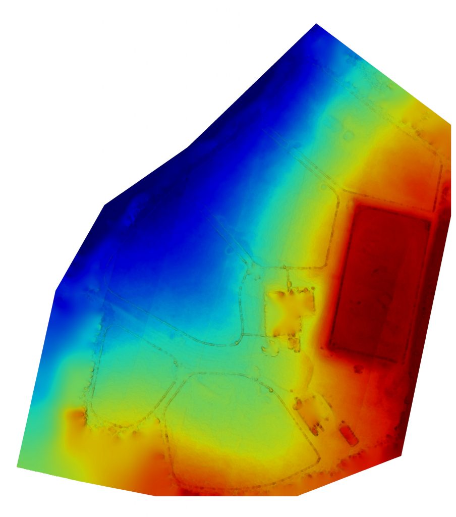
The previous image is a section of map created by specialized drone software that takes multiple images and stitches them into a single map of the entire property. In this case, the drone mapped a 10 acre farm using 98 individual high-resolution images. The drone was flown at an altitude of 200’ and did not disturb any of the horses. From the stitched map you can do multiple things including checking plant health, elevation and taking measurements.
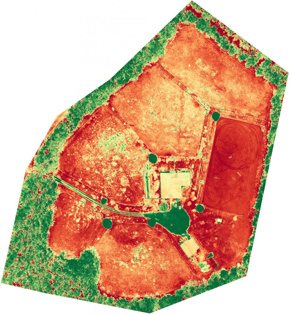
Plant Health
The plant health feature gives you a visible representation of the condition of your pastures. Green indicates healthier plant areas and red represents poor plant health. For this farm, you can see many areas in the fields are red to yellow with just a few spots of green. In some areas of the field, the plant health is red, the same as the sand ring, which is not good if you are trying to provide healthy forage for your horses.
Elevation
Knowing the elevation and topography is also important for pasture management. Identifying and mitigating erosion is important for preventing loss of topsoil and ensuring that the pasture is safe and free of trip hazards for your horse. To maximize the benefits of fertilizing, you may want to check the weather and avoid applying when heavy rain or thunderstorms are forecasted. This will help reduce fertilizer runoff on pastures that have a significant elevation change. In the elevation map below, the high spots are represented in red and the lower areas are in blue. The 2 pastures that show red, yellow, and blue variations indicate a large hill and drastic change.
Field Size
Knowing pasture acreage is key to estimating the quantity of fertilizer, weed spray, or seed needed for each field. The drone imaging software can easily generate an accurate area measurement of your pastures eliminating any guess work and preventing things like over or under fertilizing. (Field Measurement Report from Height Sight )
![]()
![]()
Next Steps
The next step for this farm is to fertilize the pastures to help the existing grass recover and start to grow. Two weeks after fertilizing, the property will be flown and mapped again to verify that the grass is recovering. Additional drone flights during the summer growing season will help to determine the need for more fertilizer or reseeding. Taking these steps will ensure that the pasture provides healthy natural forage for the horses.
Learn More
If you have any questions or would like to discuss mapping your property so you can assess your pastures, contact me directly at paul.rose@heightsight.com. If you want to learn more about the benefits of drone imaging for your property check out www.heightsight.com today!
About the Author
 Paul Rose is a partner with Height Sight LLC, a drone imaging company, and a FAA Part 107 certified drone pilot. As a junior and amateur, he competed at USEF rated horse shows in hunters and jumpers. Currently, he lives on a small farm in Moore County NC with his wife and four horses. Paul likes finding ways to combine his work in drone technology and passion for horses to help improve people’s property and the living conditions for all horses.